Cardo, meaning “heart”, was the Latin name given to a grand main thoroughfare that ran north to south and was flanked by two rows of columns a north-south street in Ancient Roman cities.
Cardos were generally lined with shops and vendors, and served as a hub of economic life, making it the “heart” of the city.
The Cardo in Jerusalem was the main commercial avenue of the city for 500 years.
Today, it is a unique experience in Jerusalem’s Jewish Quarter in the Old City.
It is is one of my favorite places to bring tourists because I think it is incredible walking through the history, like you do in Caesarea.
It was originally a paved avenue, roughly the width of a six lane highway that began by what is now the Roman Plaza Museum at the entrance of Aelia Capitolina.
Nowadays, only part of the thoroughfare is exposed, but it is not hard to imagine what it was like in ancient times.
On either side of the road were roofed columns which were used like sidewalks. The roofs gave shelter from bad weather, space for shops, and where people met and mingled.
I imagine it was probably not all that different than it is walking through Machane Yehudah Market.
The Cardo was extended during the Byzantine period under Justinian and again 500 years later by the Crusaders.
While the Roman and Byzantine have been restored in a way to help you bring the history to life, the Crusader section is now filled with shops, giving another wonderful experince.
History of The Cardo
Jerusalem was leveled and in ruins from the Siege of Jerusalem and the destruction of the Temple.
Hadrian vowed to rebuild Jerusalem from the wreckage and considered reconstructing Jerusalem as a gift to the Jewish people.
The Jews awaited with hope, but after Hadrian visited Jerusalem, he was discouraged from doing so by a Samaritan.
So, instead, Hadrian decided to build a Roman colony, which would be inhabited by his legionaries in its place.
He dedicated the city to himself and named it Colonia Aelia Capitolina after the Roman deities Jupiter, Juno, and Minerva, known as the Capitoline Triad.
This was one of the leading causes to the Bar Kokhba revolt. The revolt which took the Romans three years to suppress and enraged Hadrian. As a result, he became determined to erase Judaism from the province.
Circumcision was forbidden and Jews were expelled from the city. Hadrian took it a step further and renamed Judea as Syria Palaestina to erease the Jewish connection to the land.
Jews were prohibited from entering Aelia Capitolina on penalty of death. The one exception was for the holiday of Tisha B’Av to mourn the loss of the temple.
The ban held until the 7th century, when Jerusalem was conquered by the Arab armies of Umar ibn al-Khattab.
Under Muslim rule, Jews were allowed back into Jerusalem, and the Cardo became an Arab-style marketplace.
Rediscovery and Restoration
Remains of the Byzantine Cardo were found in the Jewish Quarter excavations, beginning in 1969.
A couple years later, a plan for preserving the ancient street was proposed, relying heavily on the Madaba map, which clearly showed the Roman Cardo as the main artery through the Old City.
The architects proposed a covered shopping arcade that would preserve the style of an ancient Roman street using contemporary materials.
By 1980, 37 housing units and 35 shops were built, incorporating archaeological finds such as a Hasmonean wall from the second century BC and rows of Byzantine columns.
The combination of old and new is also visible on the Street of the Jews, where the shops have been set into old vaults. The gallery is covered by an arched roof containing small apertures to allow for natural lighting.
Self Guided Tour
The Cardo begins as what looks like an open archaeological site. There, you can see columns topped with Byzantine-style Corinthian capitals still stand.
When you walk down the steps from today’s street level to the Cardo street level, you can see a mural of what the Cardo probably once looked like.
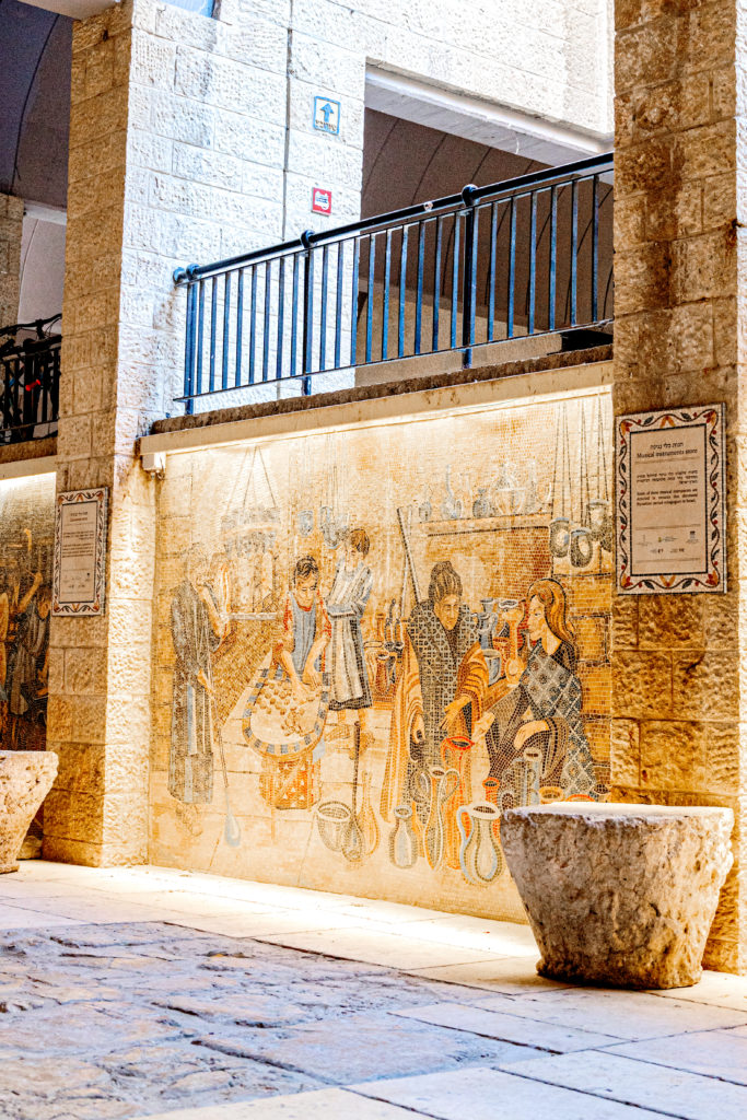

Even more interesting are the mosaic murals to your right.
Each mural displays a different type of shop with marketers that would have been in the Cardo during ancient times. Signs on the pillars explain the importance each of these shops had to the city.
As you walk further, you can find the Madaba map on display, clearly showing the Roman Cardo on the mosaic.
Further still is an underground passage where contemporary and ancient meet as shops that have been set into old vaults. This section was built by the Crusaders.
There is also a point where you can go even further down to a wall from the Hasmonean Dynasty.
If you continue down, you’ll suddenly find yourself in the busy and crowded Arab market in the Muslim quater.
The Colonnade

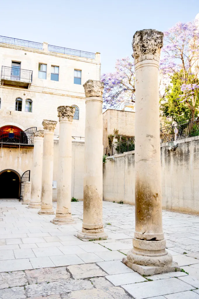
The first thing you notice when entering the Cardo is the columns.
If you look at the columns you can see that they tapper at the top. This was done as to create an optical illusion to make the columns look straight from afar. Otherwise, columns tended to look top heavy.
Note the capital at the top of the column. This style is called a Corinthian capital and is the most lavish of the three.
The northern section remnants date to the Roman period (2nd – 3rd Centuries CE). The southern section remnants date to the Byzantine period (6th century CE).
You can tell that it is from the Byzantine area rather than the Classical because it is less naturalistic. Instead, it is more stylistic, meaning it looks more cartoony.
Now, if you look up to the modern day street level, you can see date palm trees. Those mark the colonnade that ran parallel to the one you see.
The columns were discovered and reburied by archaeologists. The palm trees were planted so we’d know where they were.
A mural is painted on the wall near the entrance to the main part of the Cardo. This depicts what the Cardo would have looked like.
Madaba Map
When you walk through to the next section, you can find part of the Madaba Map.
The Madaba Map from the 6th century CE contains some of the oldest surviving original cartographic depiction of Israel and especially Jerusalem.
This map is the oldest known geographic floor mosaic in art history and was rediscovered in 1884.
It was created as part of a floor mosaic located in the apse of the early Byzantine church of Saint George in Madaba.
This section of the the mosaic depicts the Cardo as it once was.
The vaults
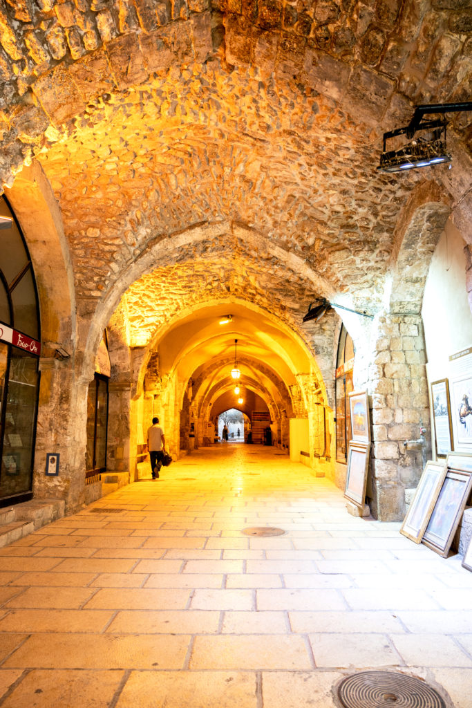

Once you leave the open air market and enter the vaults, the feel changes drastically. Note the vaulted ceiling .
While vaults were used in Roman architecture and the tradition continued with the Byzantines, this style is different.
These types of vaults are often seen in crusader structures. This style of vaults is called a ‘rib vault” and was a key feature of Gothic architecture.