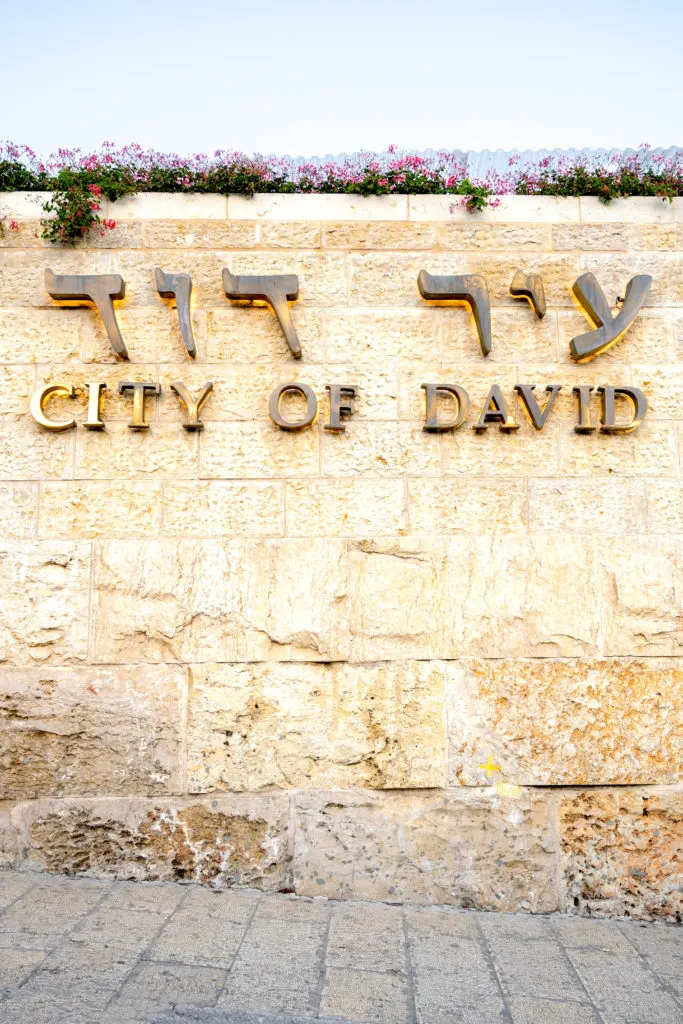
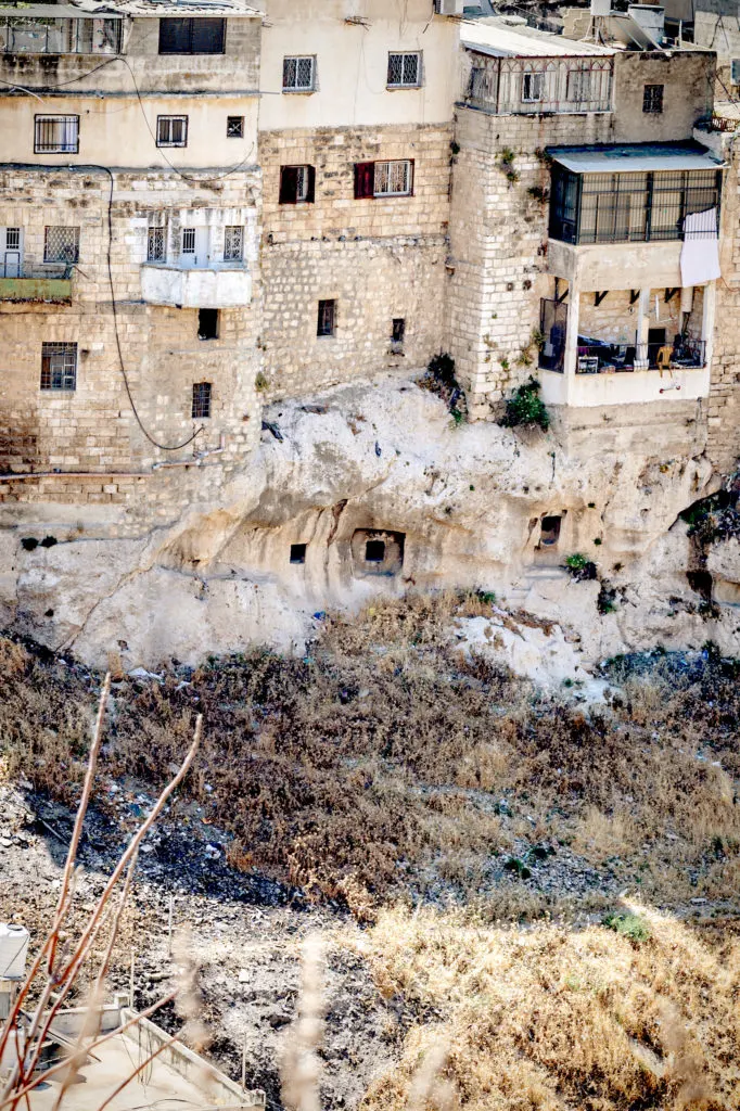
The City of David is the oldest section for Jerusalem and is actually more ancient than the Old City of Jerusalem.
The City of David National Park is a short walk from the Western Wall and is the most important archaeological site in Israel.

To me, the City of David is one of the most incredible tourist sites in Israel, and possibly the world.
I don’t quite feel like I am walking through history the way I do when I visit Caesarea, where the ruins are much younger and better preserved.
However, there is something amazing to me about seeing the remains of King David’s palace, walking up the same steps pilgrims to Jerusalem walked up to the Temple, and walking through the same canal people used to escape the Romans as they burnt the city to the ground.
Never do I feel more connected with Jewish history than I do here.
While you can completely do the site just following the paths, reading the signs, and reading the descriptions of the site on the back of the map… if you want a richer experience, I always recommend getting a tour if you can spare the extra expense.
If not, there is also a movie experience which you can see for not much more than your basic ticket price.
Also, for arguably the ultimate experience, there is a virtual reality tour. However, it only covers a relatively small section of the area.
If you really want to go all out in this experience, you can arrange it to do all three. I’ve personally yet to do this, but it is on my bucket list.
There are a number of paths you can choose between as you go through the park.
In the beginning, you have an option between the wet path and dry path. If you want to walk the wet path, you will be walking through water, and the dry path avoids that.
You can turn off along the way to Kidron Vally and see ancient tombs.
At the end of them, you have the choice to pick the Red path or Green path, which bring you back to where you started.
The Green path begins at the Pilgrimage Road, and you walk through the Drainage Tunnel.
The Red path begins with education displays and continues above ground.
After these paths, you can continue along the pink path to the Archaeological Park and the Ophel Walls for an additional entrance fee.
Or, you can leave and follow the light green path to Mount of Olives.
They are all different and worthwhile experiences.

Pro Tips!
Make sure to dress appropriately for the experience. Comfortable walking shoes are a must.
There are two routes, the dry tunnels, and the wet tunnels.
If you plan on going in the water, make sure you are wearing clothes and shoes you’ll be comfortable doing so in. My first time, I wore leather sandals, so this was not an option for me.
Wear shoes with a good grip, because some sections are slippery. In my sandals, I held onto the railing like my life depended on it.
Make sure to wear shoes that don’t get caught on things. My sandals got caught on the metal stairs at the beginning of the path a bunch of times and I was terrified I’d fall because of it.
It gets really hot in Israel in the summer (which is a surprisingly long season here), so make sure to have a hat with you and water.
I highly recommend reading the history and the description of the site described in the post below before going.
I find knowing what to look for when you get there and not having to constantly stop and read the signs allows for a much more enjoyable experience.
The first time I went, I was handed the map, which I didn’t bother to read the back of for the information since I didn’t realize how informative it was. It was also hot, so I didn’t want to stand and read the signs thoroughly, so I skimmed.
I honestly did not get that much out of it until I actually read the back of the map after the visit and enjoyed it much more my second time around, since I already read it.
I would have loved to have had something like this to read before I went because I missed so much by not.
History of the City of David and Jerusalem
The area was inhabited during the Chalcolithic period, but a walled city was only built here about 4,000 years ago.
Jerusalem is first mentioned in the Bible as Shalem (Salem) which Avraham (Abraham) visited.
About 3,000 years ago, King David conquered Jerusalem from the Canaanites.
He then left the city of Hebron for Jerusalem, established his royal city, and made it the unified capital of the tribes of Israel.
King David’s choice of Jerusalem for his capital was based in part on the presence of a water source from the Gihon Spring, the city’s strong defenses, its central location in the land of the Israelite tribes, and the fact that as a neutral territory, it could serve as a symbol of unity for the entire nation.
King David built a royal palace and brought the Ark of the Covenant into the city, transforming it into a spiritual and political center.
King David’s son, King Solomon, expanded the city to include Mount Moriah (where the Binding of Issac took place).
Here, he built the First Temple on top of Mount Moriah, also known as the Temple Mount, and his royal palace.
After King Solomon died, the kingdom was divided into two, and Jerusalem remained the capital of the Kingdom of Judah only.
Towards the end of the eighth century BCE, the Assyrians destroyed the Kingdom of Israel and its refugees flocked to Jerusalem.
They settled in new neighborhoods built on the Western Hill, around which a broad wall was constructed.
The Assyrians conquered the Kingdom of Judah, but failed to capture Jerusalem. However, about 100 years later, the Babylonians conquered the city and razed it to the ground.
The Babylonians deported the middle class and above of the Kingdom of Judah to Babylonia and left only the poor population.
Sixty years later, the Jewish population began making their way back to Israel. This is known as the Return to Zion period, which spanned 110 years.
During this period, Jerusalem and the Temple were rebuilt.
During the Second Temple period, Jerusalem expanded again towards the Western Hill, which was home to the elite and became known as the Upper City.
In the City of David, which was part of the Lower City, was generally poor, but Queen Helena of Adiabene built several palaces for herself and her family.
Then, during the Great Revolt against Roma (66-70CE), Jerusalem was once again razed to the ground.
The Roman emperor Hadrian built a pagan city in 135 CE on the ruins of Jerusalem called Aelia Capitolina, and a pagan temple on the Temple Mount. Jews were not allowed in it on penalty of death.
Jews returned to Jerusalem with the Arab conquest in 638 CE.
Over the years, the location of the City of David was forgotten, and when the Old City walls were rebuilt, the oldest section of Jerusalem was left outside of them.
While Jews continued to live in the Old City out of risk of danger, few, if any, people lived outside the city’s protective walls.
It was only when Mishkenot Sha’ananim, the first neighborhood outside of the walls, was built in 1859 that Jerusalem began to expand again.
Jewish settlement was renewed in the City of David in 1873, and in 1885, a large group of Yemenite Jews settled nearby.
It was around this time period that archaeological exploration in Jerusalem began, and discoveries made on the hill led to the rediscovery of the City of David. Since then, it has become the most excavated mount in history.
Today, the City of David has some of the most exciting archaeological finds of the ancient world and is the location of the largest number of archaeological expeditions.
The City of David National Park is one of the most important and popular attractions in Jerusalem.
Also, the Jerusalem Trail, connecting Jerusalem with the Israel National Trail, passes through the park along the Kidron Stream and through the Hinnom Valley.
Check out the National Parks and Nature Reserves page for the City of David for hours and entrance fees.
What there is to see
You can easily spend a day seeing everything in the City of David. Following is a list of most of it.
This list only includes what is within the City of David National Park and not the Jerusalem Walls National Park, within which the City of David is located and where there is even more to see.
Beit Hatzofeh Lookout
From this vantage point, you can see the mountains that surround the City of David. This is believed to be the view that inspired the line in Psalms 125 “As the mountains surround Jerusalem.”
While today the hill of the City of David is relitively low, in antiquity it towered over the deep valleys that surrounded it on almost all sides.
In fact, the eastern slope that descends into the Kidron Valley is still very steep. However, over the centuries, rubble and debris accumulated over time, so even it too is not as steep as it was in ancient times.
From this view point, you can see the Temple Mount on Mount Moriah, the Kidron Stream, the Silwan neighborhood, the slopes of the Mount of Olives, and the Ophel archaeological site.
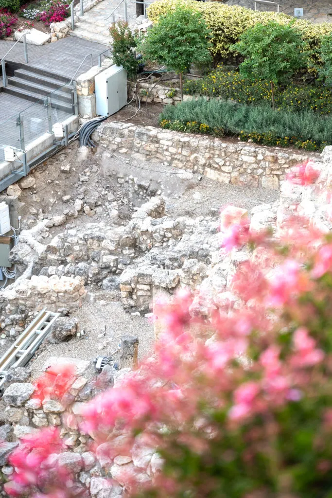
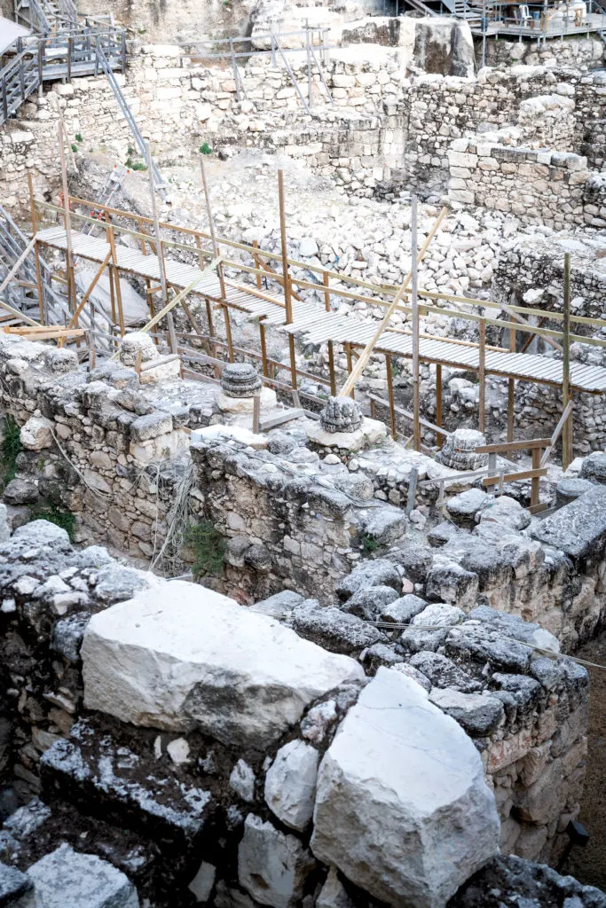
The Remains of David’s Palace
In 2005, a large stone structure was discovered beneath the ruins from the Byzantine and Second Temple periods.
Excavations carried out since then have unearthed numerous finds which indicate that it was built in around 900 BCE.
This, clues from the Bible regarding the location of David’s palace, and stately architectural elements found nearby indicate that this was in fact King David’s palace.
Evidence indicates that the palace continued to serve the royal administration of Judah until the Babylonians destroyed Jerusalem in 586 BCE.
Bullae (clay impressions used for sealing documents) bearing the names Shelemyahu ben Shobai and Gedalyahu ben Pashhur were found.
These were two high-ranking officals from the court of King Zedekiah, the last king of Judah. We see in the Navi (The Book of Prophets) that they were both fierce antagonists of the Prophet Yermiyahu (Jeremiah).
The Royal Quarter

During the First Temple period, this area was a residential area for nobles and royal officials.
The earliest structure unearthed here was a retaining wall believed to have either supported King David’s Palace or the Canaanite fortress that preceded it.
Later, during the early part of First Temple period, luxurious homes and an official archive were built here.
The houses typically were three rectangular rooms built around an open courtyard, which was the fourth room. The courtyards were where the animals were kept and household tasks took place. The houses are believed to have been two stories high.
The Royal Quarter was destroyed along with the rest of the city during the Babylonian conquest of Jerusalem.
When Nebuchadnezzar burnt Jerusalem to the ground, including the Royal quarter, the archives went up in flames too.
However, while the documents were lost, their clay seals (bullae) were hardened and persevered. Some of the names on the bullae are mentioned in the Bible.
The wall Nechemia built as part of the reconstruction of Jerusalem, as is described in the Book of Nechemia, is in this area as well.
Ancient Tombs Lookout

From the lookout, you can see across the Kidron Valley to the village Silwan, which was part of the necropolis of Jerusalem during the First Temple period. Approximately 50 burial caves have been served there.
In 1870, an ancient Hebrew inscription that read “[…]iahu who is over the house” on the enterance of one of the caves. The full name may have been Shebna (Shebniahu), who was an official with the title of “over the house” in the court of King Hezekiah.
Warren’s Shaft System
In 1867, British explorer Caption Charles Warren discovered an underground tunnel that burrowed beneath the city walls.
It was an ancient water system which leads to the Gihon Spring, which emerges on the hillside. The spring is one of the largest springs in the mountain region and supplied Jerusalem’s inhabitants with water.
Because the spring emerged outside the city, it was surrounded by a large fortification, and an underground tunnel was hewn to safely reach the water.
The water system is a network of rock-hewn tunnels intended to ensure a regular and secure water supply during times of war and siege, as well as peacetime.
For many years, the shaft was considered the main component of the Canaanite water system.
However, we now know it was only 1,000 years later, during the period of the Kingdom of Judah, that the floor level of the tunnel was lowered for reasons unknown, revealing the existence of a natural shaft.
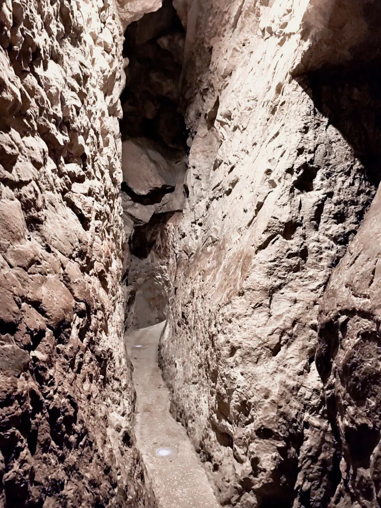
The Secret Tunnel
This tunnel was the secret underground passageway that lead to the fortified Canaanite Pool.
The Canaanite Pool and the Fortifications of the Spring House
The Secret Tunnel leads to the surface of the eastern slope outside the city walls.
The nearby large pool was cut into the bedrock 3,800 years ago and fed into by the Gihon Spring water. It served as Jerusalem’s wartime water source to be used in time of siege.
Since the pool was outside the city walls, it was surrounded by massive fortifications, part of which can still be seen today.
It has been suggested that this was the location of King Solomon’s coronation.
During the First Temple period, the Pool was filled with earth and simple homes were built upon it.
In the fill, 200 bullae and thousands of fish bones were discovered. This attests to the vibrant trade ties that existed between the Kingdom of Judea and the Kingdoms of Israel and Phoenicia, as well as the dietary habits of the inhabitants of Jerusalem in those days.
The Gihon Spring
The underlying factor in the development of ancient Jerusalem was the Gihon Spring, which is one of the largest and most abundant springs in the mountain region.
Thanks to this spring, there was human settlement here already in prehistoric times, which grew and increased from the Canaanite period and onward.
King Solomon was anointed by the waters of this spring, though exactly where is unknown.
The Canaanite Tunnel
The Canaanites directed the Gihon Spring water to the pool through a channel today known as the Canaanite Tunnel.
The channel ran along the eastern slope of the City of David, and on its way south, fed the pool. It was also used to irrigate farmland in the Kidron Valley.
Hezekiah’s Tunnel
The water system from the Gihon Spring was replaced by a more sophisticated system about 1,000 years later.
Hezekiah’s Tunnel is a long and winding tunnel, carved out to bring water from the Gihon Spring to the Pool of Siloam, located within the walls of the City of David.
When Jerusalem was preparing defenses against the approaching Assyrian army, King Chizkiyahu (Hezekiah) feared that the water flowing outside the city would be used by the Assyrian army.
He decided to protect the water source by diverting its flow by cutting a tunnel deep rock which led into the city.
The tunnel channeled water to the Shiloah Pool built within the city walls using truly amazing engineering.
In 1880, an inscription in ancient Hebrew script was discovered describing the last moments of the completion if the tunnel.
“While the hewers wielded the axe, each man towards his fellow, and the three cubits still to be hewn … the tunneling the hewers struck each man towards his fellow, axe upon axe. And the waters flowed from the source to the pool for two hundred and a thousand cubits.”
The Shiloah (Siloam) Pool
The Shiloah pool was a magnificent pool from the late Second Temple period, built by King Chizkiyahu (Hezekiah) and was fed into through the Hezekiah Tunnel from the Gihon Spring.
The hewing of the water system was a complex operation.
It required a large team of laborers to dig, transport, and build large chunks of rock (each weighing 4-5 tons). It also required skilled professionals who knew how to plan the route of the diggers underground. Amongst them were advisors with geological knowledge about the character of the rock and those with hydrological knowledge about the nature of the spring.
Hewing the rock required special tools. From the Siloam Inscription found carved into the tunnel wall, we know that axes were used in the digging. Signs of the digging can be seen in the rock walls of the water systems.
The pool was inclosed between the walls of the City of David and the new wall that he built around the Western Hill.
Steps descended from four sides to the floor of the pool. This has led excavators to posit that pilgrims used it as a mikva (ritual bath) to purify themselves before ascending to the Temple.
The steps are overlaid with stone, and underneath them are remains of an earlier pool dating from the Hasmonean period.
Today, the water flows into a rectangular pool from the Byzantine period called the Byzantine Pool of Siloam.
The Stepped Road: Pilgrim’s Ascent
A flight of stairs led up from the pool to a large colonnade. This served as a promenade for visitors to the pool.
On one side of the colonnade, a modern wall painting depicts daily life at the pool in the late Second Temple period.
A father is depicted carrying his child on his shoulders in the painting. This illustrates a debate among the Sages as to what age pilgrimage became mandatory.
One opinion (Beit Shammai) holds that it’s any child who cannot ride on his fathers shoulders and go up from Jerusalem to the Temple Mount.
Another opinion (Beit Hillel) holds that it is anyone who cannot hold his father’s hand and go up from Jerusalem to the Temple Mount.
A stepped road from the late Second Temple period was found on the western side of the pool. The street ascended along the Central (Tyropoeon) Valley.

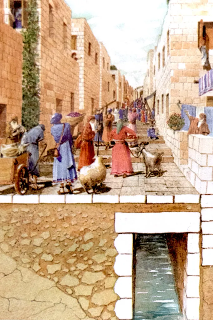
It is believed that this was the route taken by pilgrims on their way up to the Temple.
Another road from the Second Temple period was discovered east of the pool. Today, it is believed that both roads were actually part of the same thoroughfare.
The stones used to pave the street were found in excellent condition, except for a number of places where they were broken.
The pavement was apparently shattered by the Romans as they searched for people taking refuge in the drainage channel, as described by Josephus.
Below them, you can see the drainage channel that ran beneath the road.
The Byzantine Pool of Siloam
At the outlet of Hezekiah’s tunnel, part of the Byzantine pool of Siloam can be seen.
The pool was apparently built at the beginning of the Byzantine Empire.
Siloam is the Greek pronunciation of the Hebrew Shiloah.
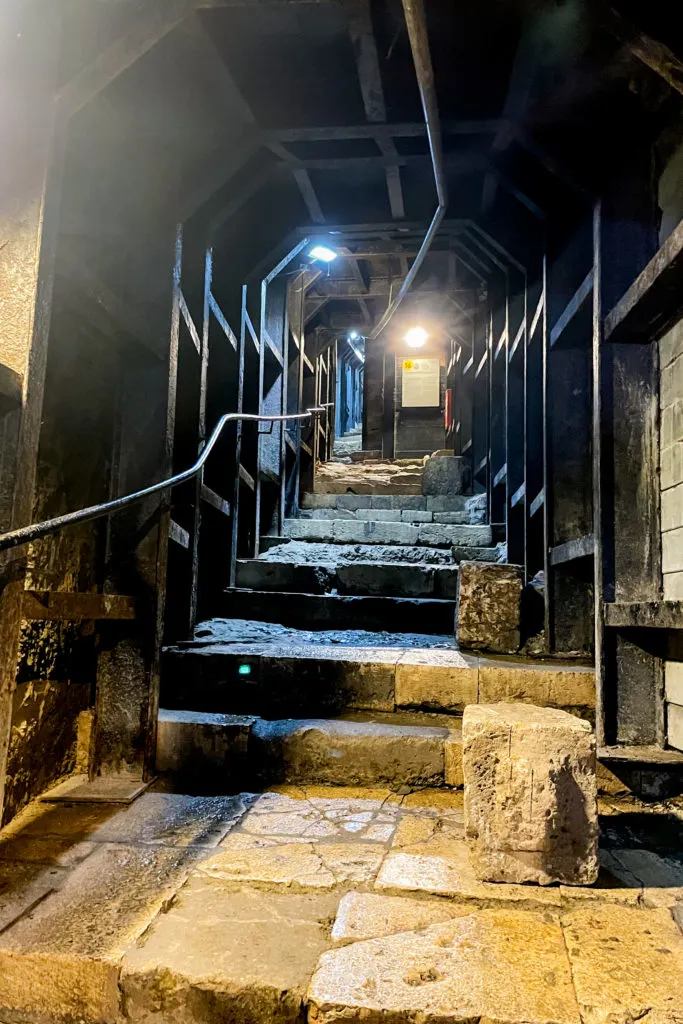
The central water drainage channel

Jerusalem’s central drainage system was built at the end of the first century BCE.
At this time, Herod rebuilt the Second Temple and substantially enlarged the Temple Mount.
This enlargement obstructed the natural flow of the water rains that collected in the Tyropoeon Valley, requiring an alternative underground drainage facility to be built.
This channel gathered water and drained it from the area of the Western Wall, southwards, passing the Shiloah Pool and flowing outside the city.
The channel also served as a place of refuge for the Jews who rebelled against the Romans.
Numerous artifacts that tell the story of Jerusalem and its destruction were found within the channel, including intact cooking pots and coins minted during the Great Revolt.
At the turn of the 19th century, various sections of the canal were excavated. However, excavation was only completed in 2011, and the canal was cleared.
Today, visitors can walk along its length to return from the Pool of Siloam to the entrance to the city of David (and even continue to the Davidson Center for an additional fee).
The northern part of the canal was cut into the rock and covered with stone vaults. In this section, Charles Warren discovered one of the Western Wall stones.
It had fallen during the construction of the Temple Mount and became wedged between the canal walls. The stone was left there, hidden deep beneath the ground.
The southern part of the canal was apparently added later and was built on the surface of the descending slope.

Its two parallel walls were covered with flat stone slabs that supported the stepped road used by the pilgrims. The several cisterns that the builders encountered were integrated into the path of the canal.
In the debris that accumulated in the drainage canal, archaeologists found a wealth of artifacts that had fallen from the road above.
These included thousands of Second Temple period coins, a rare silver shekel minted in Tyre, a gold bell ornament (similar to those that adorned the Kohen HaGadol’s robes), a Roman sword, and clay seals verifying the purity of items used for Temple offerings.
Other artifacts tell the story of the canals used as an underground refuge by the rebels who fled the Roman destruction of Jerusalem.
Along the path inside the canal are a number of manholes that opened into the street above, as well as secondary channels branching out from the walls of the main conduit.
Towards the end of the route is a cistern dating to the First Temple period, which was one of the cisterns integrated into the canal.
Upon exiting the cistern, the path leaves the canal and turns east. Here stands the bedrock adjacent to Mount Moriah and the foundation stones for the Western Wall, which were laid down more than 2,000 years ago.
Givati Excavations

This area served as a parking lot until 2007, when excavation began. Since then, structures from ten time periods spanning about 2,000 years were found in this area.
The earliest structure dates back to the Biblical period and the latest to the early Islamic period.
The main findings from this excavation were public and residential houses from the First Temple period, an enormous fortification that includes an artificial slope from the middle of the Second Temple period, remnants of buildings, mikvas, and water cisterns from the end of the Second Temple period, a massive late Roman period villa which includes extravagant rooms, a large Byzantine period structure in which
a cache of gold coins was found, and a market from the early Muslim period.